This post is also available in:
![]() Deutsch
Deutsch ![]() Français
Français ![]() Italiano
Italiano ![]() Português
Português ![]() Español
Español
GEOGRAPHY OF SOUTH AMERICA
South America occupies an area of 17,815,000 sq km, nearly half of the area is occupied by Brazil with 8,512,000 sq. km it’s the largest country in the continent, in second place is Argentina (2,780,000 sq. km), followed by Peru (1,285,000 sq. km). South America accounts for about 12% of the world land area and houses only 5.69% (370,000,000 people) of world’s population.
The continent extending from north to south for about 7,600 km from Punta Gallinas, Colombia, to Cape Horn, Chile and has a coastline of 26,000 km. South America is washed to the north from the Caribbean Sea, to the west from the Pacific Ocean, to the east from the Atlantic Ocean.
South America it’s crossed from Equator and the Tropic of Capricorn, while to the north Panama isthmus connecting it to Central and North America. Southern America includes 12 countries (Argentina, Bolivia, Brazil, Chile, Colombia, Ecuador, Guyana, Paraguay, Peru, Suriname, Uruguay, Venezuela) and three dependencies (Falkland (United Kingdom), South Georgia and the South Sandwich Islands (United Kingdom) and French Guiana (France)).
A LONG MOUNTAIN CHAIN
South America presents a massive mountain system, the cordillera of the Andes, which stretches from Panama isthmus to the north, to Cape Horn to the south, along the western edge of the continent, along the coast of the Pacific Ocean for about 7,200 km, with an average width of 240 km.
To the east of the Andes there is the great tropical rainforest of Amazon with the big river basins of the Amazon, Orinoco and Paraná. The Amazon Rainforest coincide largely in the basin of the Amazon River and its numerous tributaries and covers an area of approximately 6,000,000 sq km, it’s included for most part in Brazilian territory, to a lesser extent, Colombia, Ecuador, Peru, Bolivia, Venezuela, Suriname, Guyana and French Guiana.
The continent also contains arid regions such as Patagonia, a vast land with an area of 900,000 sq km and the Atacama Desert, which covers an area of over 130,000 sq km in the northern part of Chile.
[divider]
[divider]
THE LARGEST RIVER BASIN OF THE EARTH
The Amazon river, over 6,400 km long, it has the largest drainage basin in the world, about 6,915,000 sq. km, which is equal to 38% of the area of South America, it also contends the primacy of the longest river in the world to the Nile. Among other rivers in South America are of primary importance the Paraná (2,570 km in length, which became 4,700 km if one considers the courses of the Paranaiba and Rio de la Plata), with a drainage basin area of 1,600,000 sq. km flowing between Brazil, Paraguay and Argentina, which occupies approximately 17% of the total area of South America; the Orinoco (2,400 km long with a drainage basin area of 880,000 sq km) that runs between Colombia and Venezuela.
The most important lakes of the continent are in the Andean regions: Lake Titicaca (8,300 sq km on the border between Peru and Bolivia), Llake Poopó (Bolivia), and Lake Buenos Aires (between Argentina and Chile ).

Among the islands, as well as those who are in the Caribbean Sea, which are usually considered part of Central America, South America includes other islands such as the Galapagos, Easter Island (in Oceania, but belongs to Chile), Juan Fernández archipelago, the island of Chiloé, Tierra del Fuego, Fernando de Noronha Archipelago and the Falkland Islands.
GEOGRAPHICAL CURIOSITIES OF SOUTH AMERICA
Among the curiosities, South America contains the highest waterfall in the world, Salto Angel (979-meter jump); the largest river in water flow rate, the Amazon; the longest mountain range of the world, the Andes; one of the most dry deserts, the Atacama Desert; the largest rainforest, the Amazon rainforest; the highest capital, La Paz in Bolivia; and the southernmost city in the world, Ushuaia, Argentina. The lowest point in South America is the Laguna del Carbón (-105 m below sea level), in Southern Argentina, while the highest mountain in South America, is the Aconcagua (6,962 m) in the cordillera of the Andes also in Argentina, near the border with Chile. The average altitude of the continent is 590 meters.
[divider]
[divider]
CLIMATE OF SOUTH AMERICA
Extent between the Equatorial area and Antarctica, South America presents considerable differences in climate, most of the territory receives significant rainfall, especially the equatorial belt is characterized by a very rainy climate, with rainfall distributed throughout the whole year with 1,500-2,000 mm on average.
To the south and north of the equatorial belt rainfall decreases, alternating with dry winter and rainy summers, also the most remote areas from the influence of the ocean, as some parts of the northeast of Brazil, are subjects to periods of prolonged drought.
The strip of land south of the Tropic of Capricorn has a temperate climate. Another area characterized by significant rainfall is that of southern Chile because of the influences from the Pacific Ocean.
By contrast the ocean influences cause to the territory of coastal northern Chile and central Peru considerable dryness.
In the area of the cordillera of the Andes the climate varies in relation to the altitude, it’s in fact, tropical in the plains, temperate or subtropical in the intermediate areas, and cool climate in the mountains.
[divider]
[divider]
TOURISM IN SOUTH AMERICA

As for tourism, according to the statistics of the World Tourism Organization (WTO), South America with 18,800,000 tourist arrivals in 2006 represents 2.2% of world tourism.
The most visited countries in South America are Brazil, Argentina and Chile.
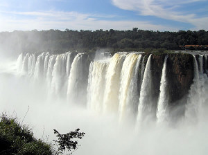
South America presents innumerable attractions for tourists. We move from archaeological sites to colonial towns. Up to the wealth of countless natural beauties: the Andes, the Amazon River, deserts, volcanoes, glaciers, the Amazon rainforest.
[divider]
[divider]
This post is also available in:
![]() Deutsch
Deutsch ![]() Français
Français ![]() Italiano
Italiano ![]() Português
Português ![]() Español
Español